
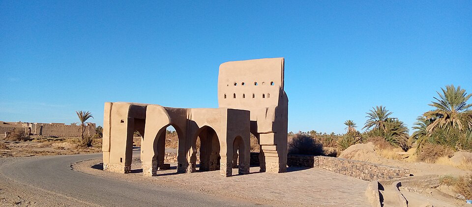

Sijilmassa’s importance as a caravan city is easier to establish than its street plan. At this archaeological site beside Rissani, in southeastern Morocco’s Tafilalet oasis, written accounts of trade have long outpaced the physical evidence for how people organised the city. Water structures offer one route into that less visible history.
A 2015 field report by Thomas Soubira and colleagues described pipes, a large tank and several kinds of pits uncovered by a Moroccan-French archaeological mission. Their value was not simply that they showed water engineering. Their construction and connections helped the researchers examine urban organisation at a site where much of the surrounding architecture survives poorly.
A trading centre, and a place to live
The French culture ministry’s archaeological account places Sijilmassa’s foundation, according to written sources, in the middle of the eighth century. It became a major link between North Africa and the Sahel, the belt south of the Sahara. Control of the city mattered to successive dynasties because of its position in trans-Saharan commerce and the gold trade.
That history does not supply a complete picture of everyday space. A trading centre also needed buildings, water storage and ways to move water between places. Knowing that caravans passed through does not locate a household, explain a pipe or date a wall.
The distinction resembles the approach needed at Volubilis, where homes, workshops and agricultural surroundings matter alongside public monuments. The periods and building traditions are different. The common task is to connect evidence of economic importance with evidence of how a city worked.
What the pipes and tank revealed
The 2015 report covered excavations through that year’s field season. In one sector, the team described a large tank built with a hard, lime-rich material and an internal coating. Terracotta pipes were protected by casings of stone and mortar. The researchers contrasted the care invested in these structures with the earth construction of walls and floors.
They argued that connected water structures were evidence of an organised urban system. Their survival also created an uneven archaeological picture: carefully built water infrastructure could remain legible where other parts of the settlement had eroded or been disturbed.
But a shape does not settle a function. One circular pit looked like a well, yet the researchers considered a manually filled cistern, a container for stored water, because a connection to groundwater had not been demonstrated. Other pits were interpreted more cautiously. Context was needed to distinguish water supply, storage and waste disposal.
Dates were another limit. The materials and techniques were used across long periods, so they did not provide a precise date on their own. The team placed the hydraulic structures within a broad eighth-to-thirteenth-century sequence. It also said that archaeological evidence for how water was obtained remained missing from its investigation. A possible distribution role for the large tank was an interpretation, not a fully reconstructed supply network.
More than one urban footprint
The same field report challenged the image of a vast walled city expanding continuously from its foundation until a single abandonment. The excavated sequence instead pointed to successive, and sometimes potentially contemporary, settlement areas occupying different parts of the site.
That matters when reading ruins. Visible standing walls need not all belong to Sijilmassa’s medieval commercial peak. The researchers reported later dates for wooden beams in some standing structures. Nor did the decline of long-distance trade erase all later occupation: the culture ministry account describes partial reuse by religious and educational institutions.
Oasis water management has its own changing history. Sada Journal’s account of khettaras and water-sharing rules examines a different form of infrastructure. It should not be used to identify every buried conduit at Sijilmassa as a khettara.
Later excavations add another layer
The 2015 report is an interim research account, not the last word on the site. MAP reporting carried by Le360 in July 2025 attributed further discoveries to Morocco’s National Institute of Archaeological Sciences and Heritage, known as INSAP. These included remains of a residential quarter, houses and lanes, parts of the great mosque complex and material evidence of a mint.
In an August 2026 interview reported by GEO, excavation director Asmaa El Kacimi emphasised what broader excavation areas reveal compared with isolated test trenches. That is a reminder that explanations for the site’s elusive urban plan include research methods as well as preservation. This article uses the 2015 findings as a dated case study, not a settled account of the whole city.
Those reported findings expand the physical picture. They do not make every earlier interpretation final or establish that every structure belongs to the same period. Sijilmassa is better understood by keeping texts, excavated layers and successive research campaigns in conversation than by fitting every ruin into one view of a medieval gold city.
Sources and method: This historical explanation draws on the full text of the 2015 Nyame Akuma field report, the culture ministry’s site account, a researcher’s overview and attributed reporting on later excavations and interpretations. It is not a new excavation report or an on-site condition survey. No present-day access, admission or restoration-completion claim is made.
Lead photograph: gate of al-Mansuriya beside the Sijilmassa archaeological area, photographed on 21 January 2021 by Hmidanix, via Wikimedia Commons, CC BY-SA 4.0. Archive view, not the excavated tank. Although the file title identifies it with Sijilmassa, Thomas Soubira’s research overview places this much-photographed gate, in all probability, in the neighbouring ksar of al-Mansuriya. The image does not establish a medieval construction date. Reduced-resolution reproduction; display cropping may occur. The photograph and any adaptation remain under CC BY-SA 4.0. No generative changes.
